

Super El Niño Event Underway – what’s in store for Hawaii’s moderate climate?
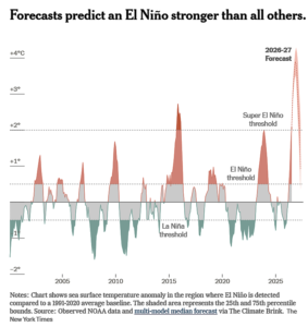
A powerful El Niño already beginning to roil weather around the world may push the monthly global average temperature past 2C of warming for the first time on record. Scientists predict Earth’s current climate pattern this year is being supercharged by extreme weather events and which are now pushing global temperatures to record highs. In short, if 2026 is not the hottest year on record, 2027 surely will be.
The ongoing El Niño has become more powerful over the past month and will likely continue to strengthen well into 2027, according to updated data from the National Weather Service. A “Super El Niño” will no doubt increase the risk of extreme weather events within the United States and elsewhere with record-setting hot temps, extreme fires, and disruptions to water supplies, agriculture, and economic fallout for the global economy.
The odds of a month that’s 2C hotter than pre-industrial levels increased significantly in recent weeks as meteorologists upped their estimates for the current El Niño, which is likely to be the strongest in modern history. The hot El Niño is coming on top of a possible acceleration of global heating that scientists are still trying to unpack.
This summer has brought record heat and severe wildfires, as well as pushing up global temperatures. The current event of a building El Niño is expected to worsen drought and strain food production.
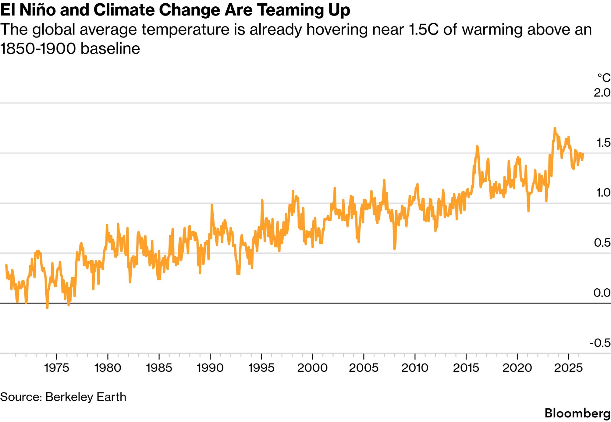
The earliest suggestion that 2C might be a reasonable upper limit for manageable climate change goes back to the mid-1970s. Four decades later, nearly 200 countries agreed in Paris to set it as their goal to limit climate change — while striving to keep heating below 1.5C as a long-term average of 20 years or so.
The global graphics below represent forecast scenarios in red, and illustrate how the current super El Niño event is already reaching unprecedented heights and by the end of the year will no doubt produced record setting global temperatures never observed before.
A super El Niño event of this magnitude is expected to drive significant weather impacts, which could end up stronger and more longer-lasting. Global temperatures could reach new highs, while patterns of drought, floods, heat and humidity shift across the planet.
Sea surface temperature forecasts already suggest this El Niño will top the most historically intense events on record, potentially by a wide margin. Those El Niño events occurred most recently in 1972-73, 1982-83, 1997-98 and 2015-16.
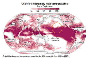
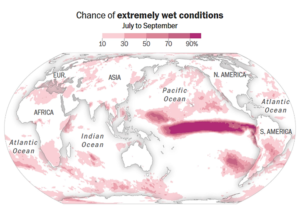
Warmer seas that develop in this remote part of the world, highlighted in the above map, cause thunderstorm patterns to change there. That has cascading effects on weather patterns across the planet as those storms transfer heat from the ocean to the atmosphere. In other words, what happens in the tropical Pacific doesn’t stay there.
The latest outlook of possible extreme weather ripple effects from this year’s El Niño is based on three-month forecast data released in early July. These scientific data and El Nino outlook doesn’t predict specific weather events. Instead, it shows where unusually extreme climate conditions are more likely, often because of frequent storms or persistent departures from normal weather patterns. That’s because warmth that builds up along the equator in the Pacific Ocean gets released into the atmosphere and spreads around the planet.
- This year’s phase is expected to have a profound, upward influence on global temperatures, with more than an 80 percent chance for 2027 to become the warmest year on record.
- Through September 2026, around 2.8 billion people across the planet have at least a 10 percent chance of experiencing temperatures that are in the top 5 percent of historical values for the time of year.
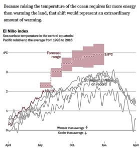
Already, sea surface temperature forecasts suggest this El Niño will top the most historically intense events on record, potentially by a wide margin. The El Niño events of recent times occurred in 1972-73, 1982-83, 1997-98 and 2015-16.
Currently, an El Niño of this magnitude is expected to drive significant weather impacts, which could end up stronger and more longer-lasting. Global temperatures could reach new highs, while patterns of drought, floods, heat and humidity shift across the planet.
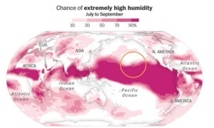
Warmer seas that develop in this remote part of the world, highlighted in the following maps and graphs create thunderstorm patterns with extreme energy and drive a global climate feed-back loop impacting weather and temperature norms across the globe. All together, that has a cascading effect on normal weather patterns and seasonal weather patterns. As a result super storms are on the increase and with the power to transfer heat from the ocean to the atmosphere well above historic weather norms.
In other words, what happens in the tropical Pacific doesn’t stay in one area but has a cascading weather effect across the planet — as a weather and climate system, it’s all connected.
The latest outlook of possible extreme weather ripple effects from this year’s El Niño is based on three-month forecast data released in early July. The scientific data and El Nino outlook doesn’t predict specific weather events, but instead offers insights into where unusually extreme climate conditions are likely, and often because of frequent storms and the persistent departure from historic and normal weather patterns.
What’s Ahead for 2026-27
This year’s El Nino cycle is expected to have a profound, upward influence on global temperatures, with more than an 80 percent chance for 2027 to become the warmest year on record. That’s because warmth that builds up along the equator in the Pacific Ocean gets released into the atmosphere and spreads around the planet.
Through September 2026, around 2.8 billion people across the planet have at least a 10 percent chance of experiencing temperatures that are in the top 5 percent of historical values for the time of year.
In the global graphics below, the forecast scenarios are represented in red, and illustrate how the current El Niño event is already reaching unprecedented heights and by the end of the year will produced record setting global temperatures never observed before in modern times.
How much is climate change to blame?
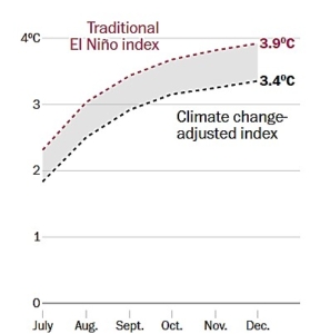
Ocean temperatures are rising, mostly because of Global Heating compounded by rising temperatures liked to global Climate Change. These climate effects and increasing temperatures are directly linked to El Niño to increasing cycles. The Earth’s atmosphere can hold about 4 percent more water vapor for every degree Fahrenheit of warming, which amplifies precipitation extremes across the planet.
To distinguish warming caused by El Niño from the long-term background warming of the oceans driven the CO2 emissions, scientists have developed a new climate change-adjusted index, now used by the National Oceanic and Atmospheric Administration and climate agencies in Europe, Australia and New Zealand.
Rather than looking only at temperatures compared with the average in the central equatorial Pacific, the new index compares temperatures in the targeted region with temperature across the world’s tropical oceans. That relative temperature difference is closely tied to shifts in tropical thunderstorm activity, which further fuels weather extremes associated with El Niño around the world, and more specifically and locally; the Hawaiian Islands.
Scientists and climatologists have begun measuring how much warmer El Niño effects in regions compared with historic norms, and with a greater focus on the Earth’s tropics region which are increasingly impacted by El Nino events, and most notably, they are a direct contribution to much higher global humidity outcomes than historic norms, and which have been shown to increasingly impact population centers and economies within the affected regions.
In short, rather than just comparing average temperatures within the central equatorial Pacific, using the new global index scientists can more effectively track the effects of an ever hotter planet with tools that compare temperatures in affected regions with historic norms and global average temperatures, All this includes a specific focus on tropical oceans which are increasingly serving as the global heat-sink for an ever hotter world addicted to burning fossil fuels.

Leave a Reply
Join the Community discussion now - your email address will not be published, remains secure and confidential. Mahalo.