Kilauea summit (Halema’uma’u) latest eruption report
Eruption Report September 2023 –
 Kilauea, one of the most active volcanoes in the world, began erupting Sunday, September 10th, after a two-month pause, displaying glowing lava that is a safe distance from people and structures in a national park on the Big Island, but lasted only about one week. Kilauea now is quite again — for the moment.
The Hawaii Volcano Observatory previously reported the latest eruption was first observed in the afternoon at the summit of Kilauea.
The observatory said gases released by the eruption will cause volcanic smog downwind of Kilauea. People living near the park should try to avoid volcanic particles spewed into the air by the eruption, the observatory said.
The volcano’s alert level was raised to warning status and the aviation color code went to red as scientists evaluate the eruption and associated emissions hazards. On Sept. 12th, Sulfur Dioxide (SO2) emission rate from Kilauea had risen to nearly 49,000 tons per day, gassing Big Island Kona Coast residents who watched their skies and sunsets turn a smoggy gray.
Earlier in June, Kilauea erupted for several weeks, displaying fountains of red lava without threatening any communities or structures. Crowds of people flocked to the Big Island’s Hawaii Volcanoes National Park, which offered safe views of the lava.
The September 12th eruption began rather suddenly after a period of elevated seismic activity over the past month. Prior to that recently the volcano has been relatively quiet, until a tiltmeter detected a strong shift in ground terrain shortly before lava broke out. Based on initial measurements, the new eruption appears more vigorous than the June eruption. Volcanologists tell us that start-stop eruption predictions are difficult at best to estimate. Locals often associate a famous line from a popular movie with Kilauea’s unpredictable eruption schedule, …“I’ll be back”.
Kilauea lies east of Mauna Loa and is considered to be Earth’s most active volcano. It covers about one-seventh of the island of Hawaii (southeast) and rises to about 4,090 feet (1,250 metres) above sea level. Kilauea is also Hawaii’s second-largest volcano and its last “major” eruption in 2018 destroyed more than 700 homes and deactivated the Puna Geothermal Venture (PGV) energy operations located on the south-east flank of the volcano. PGV began re-supplying electricity to the Hawaiʻi Island grid in 2021, two and half years after the previous eruption. However, the state’s only geothermal energy operator PGV has since failed to achieve pre-eruption power production levels.
Eruption Report June 2023 –
The summit eruption at Kīlauea volcano on the Big island has paused. Eruptive activity — which has been confined to Halemaʻumaʻu crater within the summit caldera at Kīlauea has resumed its non-eruptive state, with clear skies returning to Hawaii Island. — No unusual activity has been noted along the volcano’s East Rift Zone or Southwest Rift Zone, since June 19th, 2023.
 Kīlauea Erupts After a 3 Month Pause
HVO volcanologists observed an increase in earthquake activity and ground deformation hours prior to the eruption, suggesting the movement of magna beneath the surface of Kīlauea.
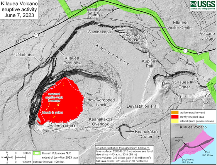
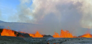
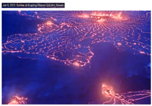
A magnificent display featuring mesmerizing fountains of vibrant, molten lava bursting hundreds of feet into the air began on June 7, 2023 at 4:44 a.m. within Halemaʻumaʻu crater.
Fiery Deluge Mesmerizes
According to USGS Hawaiian Volcano Observatory, the eruption was first detected through webcam images showing glowing presence at the summit in the early morning. This same webcam system is available for public viewing on the USGS web site 24×7, offering various live views of the eruption in real time – it’s impressive: https://www.youtube.com/usgs/live
 Opening phases of volcanic eruptions are generally dynamic, and Kilauea did not disappoint USGS scientists or the general public.
The largest lava fountain was consistently about 50 feet high; during the early phase of the eruption, with lava fountain bursts that reached at an estimated 200 feet in height as lava inundated much of the crater floor (an area of approximately 370 acres). By 8:00 a.m. on the morning of the eruption about 10 meters (33 feet) depth of new lava had been added to the crater floor. Lava fountain heights have decreased since the initial eruption onset, and as of this writing, are averaging between 20 and 30 feet high.
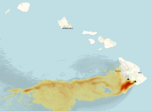
USGS forecasts are updated daily as to Kilauea’s eruption progress and volcanic gas emissions. The initial Sulfur Dioxide and Carbon Dioxide volcanic emissions rate was measured on June 8th at 65,000 tons/day, but by June 12 emissions has risen to 11,000 tons/day, with prevailing winds driving emissions into West Hawaii and primarily impacting western Hawaii Island in the form of hazy skies, making it difficult to breath for many local island residents.
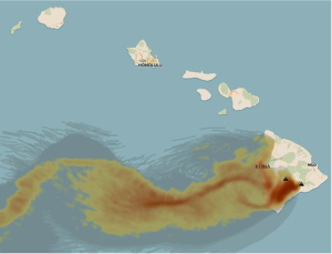 Vog is primarily a mixture of sulfur dioxide (SO2) gas and sulfate (SO4) aerosol. SO2 (invisible) reacts with oxygen and moisture in the air to produce SO4 aerosol (visible).
Sulfur Clouds
Sulfate aerosols are very small particles consisting of particulate matter less than 2.5 micrometers in diameter and are referred to as PM2.5. Other sources of PM2.5 include vehicle exhaust and smoke from fires. Vog contains mostly SO2 and PM2.5, in contrast to urban, industrial, fossil fuel power plants, and other pollution sources, which also contain additional toxic contaminants, such as ozone and hydrocarbons.
 Kilauea’s eruptive volcanic emissions, especially sulfur dioxide, can also turn local area skies into a strange yellow hazy tint, and when the tainted air comes in contact with cars and buildings. for example, it leaves a toxic residue or hazy coating on windows and can damage painted surfaces, including vehicles, and harmful to agriculture.
Kilauea’s eruptions are a wonderful reminder of the natural world’s majestic power which is so much greater than a tourist attraction, but at a price for Hawaii Island residents, and the rest of the state when the winds are right.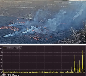
Eruption Updates:
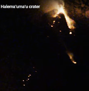
Halemaʻumaʻu Lava Lake Observations June 14th:
Activity continues to decrease. Fountaining is diminished on the southwestern Halemaʻumaʻu crater floor, with only a few small fountains remaining. The extent of active lava has retreated further such that all activity is now concentrated in the southwestern and central portions of Halemaʻumaʻu Crater.
An active lava lake is centered within the central area and is fed by a vent in its northeast corner. This feature is the “western” lake from prior eruptions that has been reactivated along with a smaller circular pool just southeast of the lake.
The vent on the southwest wall of the caldera continues to spatter and feed lava onto the westernmost part of the crater floor. The surface of the western active area has not risen since yesterday. All previously active lava features in the northern and eastern portions of the crater now appear to be stagnant.


Leave a Reply
Join the Community discussion now - your email address will not be published, remains secure and confidential. Mahalo.